Smart Projects Showcase
The City of Norwood Payneham & St Peters has already started its smart city journey.
There are a number of smart projects, programs and initiatives already in action across the Council. These initiatives represent the strong smart city foundation that this Smart City Plan will build-upon.
Smart School Crossing an Australian first

William Street, Norwood (St Joseph’s Memorial School) is now home to Australia’s first Smart School Crossing, which collects high quality data that is informing better transport planning decisions and improving road and pedestrian safety.
In partnership with SAGE Group, the crossing allows for:
- measurement of incoming and outgoing traffic speed (bidirectional radar)
- the ability to change the operational aspects of crossing signals
- analysis of pedestrian movements (anonymised Bluetooth and wi-fi detectors).
Data indicates that traffic speeds are slowing during the school drop-off and pick-up periods since the installation of the crossing.
Smarter Parade, Norwood

The Council is investigating smart infrastructure as part of The Parade Norwood streetscape redevelopment, including the following examples:
- digital kiosks – to provide interactive content to the public about events and wayfinding information
- smart lighting – which turns on/off automatically during twilight periods
- people counter sensors – to monitor visitation to Adelaide’s premier main street.
The Parade, Norwood streetscape redevelopment is a part of The Parade Masterplan and is scheduled to be completed in 2024.
Related website:
Public electric vehicle charging stations

There are six publicly accessible electric vehicle (EV) charging stations, provided by JOLT and Evie, in operation across the City of Norwood Payneham & St Peters.
EV charging station locations:
- Webbe Street Car Park
- Osmond Terrace, Norwood on-street parking
- Linde-Dunstone Grove Reserve Carpark
- Borthwick Reserve, Portrush / Payneham Road
- Payneham Community Centre, Payneham Road
- Glynde Corner Car Park.
In collaboration with JOLT and Evie, the Council aims to provide up to 16 EV charging stations across the City of Norwood Payneham & St Peters over the next 15 years.
Expansion of free Wi-Fi

Free Wi-Fi is available to residents and visitors at the Council’s three Libraries.
The Norwood Town Hall is currently being investigated as another potential location to offer free public Wi-Fi.
Council parks and other facilities will be added to the network in the future.
Related website section:
Smart irrigation in our parks and streets

The Council continues to install smart irrigation systems in local parks and reserves, which helps create cooler, greener and more sustainable places for us to live, visit and enjoy.
Smart irrigation systems work to reduce water consumption through the implementation of sensors to monitor soil moisture and weather patterns.
Smart irrigation has already been installed at Felixstow Reserve, Scott Street Reserve and Syd Jones Reserve.
A Bluetooth/battery irrigation controller was also installed in the median strip on The Parade, Norwood, which allows council staff to alter watering settings from the footpath via their phones.
Current and future upgrades, where landscaping is included, will also prioritise the provision for smart irrigation.
For example, the redevelopment of Burchell Reserve will incorporate smart irrigation and water sensitive urban design.
Related website section:
Smart corporate energy actions
 The Council has made a commitment to reduce the energy consumption of its buildings and infrastructure.
Smart energy actions implemented by the Council include:
- installation of 66 kW solar panels and battery storage at the Norwood Town Hall
- future budget provision to add solar panels and battery storage at other Council facilities
- transition to LED lighting from mercury vapour street lights
- introduced e-bikes for Staff to use
- energy audits of key council assets and facilities.
For more information on the Council's energy actions, download:
Capturing tree canopy coverage using LiDAR technology

In a first for metropolitan Adelaide, the Council collaborated with Adapting Northern Adelaide, Resilient South and AdaptWest to capture a baseline of tree canopy cover and height for all trees over three metres.
Using LiDAR (Light Detection & Ranging) technology, high resolution, 3D tree data was captured by flying across the Adelaide region.
As we experience longer and hotter heatwaves, this data is critical to help the Council plan for trees in our backyards, streets and neighbourhoods.
Together with Resilient East, the Council is getting climate ready.
Find out more:
Heat Mapping using Aerial Thermal Sensing

Heat mapping identifies the hottest areas across the Council, generally as a result of a reduced number of trees.
The high-resolution maps show where urban hot spots are located in relation to buildings, roads, trees and other vegetation.
The Council uses the heat maps to inform planning, tree planting and greening programs to create cooler more liveable places in our community.
Council’s Tree Strategy has used heat mapping technology to inform a number of policy outcomes such as hot spot areas – where trees are to be planted.
Related webpage:
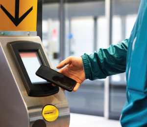
Smart parking
 The Council partnered with eSMART21, to undertake a Smart Parking Pilot Project in the Council owned Webbe Street, Norwood car park.
The Project included the monitoring of six car parking bays with the Autofine Smart Parking and Management System to understand vehicle occupancy rates and overstays against the two hour parking time limit controls.
If fully implemented, the Smart Parking technology will lead to an increase in vehicle turn-over, which is a benefit to local businesses.
Related webpage:
Zero emission corporate vehicles
 The Council has transitioned the majority of its fleet of passenger vehicles to hybrid electric vehicles.
It is expected the Council’s entire fleet will transition to zero emissions by 2030.
For more information on the Council's energy actions, download:
To find out about more smart initiatives and projects, refer to page 13 of the Smart City Plan
Pages in this section:


More information
For all Smart City related enquiries, contact the Smart City Steering Group
To keep up-to-date on smart city projects and initiatives, subscribe to the Council's bi-monthly eNewsletter, Your NPSP. Register now >